 Above: - In The Box Is A Feed Of Current Arkansas Watches, Warnings & Advisories.
Click The Bold & Underlined Text Inside The Box To Read Each Bulletin. If Feed Is Not Current, Click Here. Or,
Use The NWS LZK Active Arkansas Watch & Warning Map..Located Directly Above & To The Right.


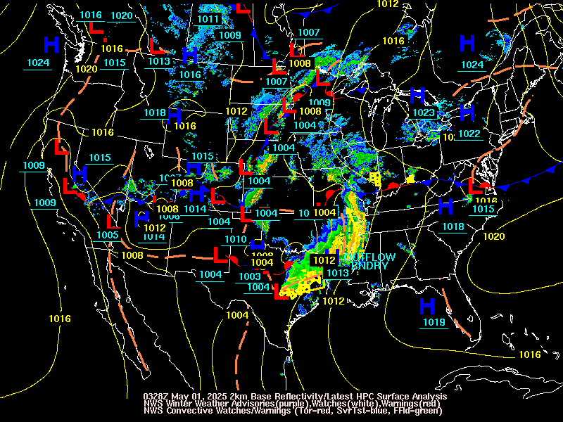
Above: WFO (LZK)'s GOES East - IR Loop, (KLZK)-WSR-88D Composite Reflectivity Loop, &, Active Advisory, Watch, & Warning Maps.
Click The Maps To Zoom Into Your Area Of Interest.


Above -- The Latest Real Time Official Public Domain RIDGE Imagery From Arkansas's 9 Regional National Weather Service (NWS) NEXRAD WSR-88D Doppler Weather Radar Sites Located Near: Tulsa, OK., Springfield, MO., Paducah, KY., Fort Smith, AR., North Little Rock, AR., Memphis, TN., Dallas - Ft. Worth,TX., Shreveport, LA., & Jackson, MS. Click On The Thumbnail Images To Go To Corresponding Imagery. Click to Read the (NWS) Arkansas Area Forecast Discussion (AFD), Arkansas Area Weather Summary (AWS), Arkansas Hazardous Weather Outlooks (HWO), Arkansas Hydrologic Outlooks (HYD), Severe Thunderstorm, Tornado, & Flash Flood Watch County Notifications (WCN) & Watch Outline Updates (WOU)'s, Short Term Nowcasts (NOW)'s, Significant Weather Alerts (SWA)'s
, Severe Thunderstorm Warnings (SVR)'s, Tornado Warnings (TOR)'s, Urban & Small Stream Flood Advisories (FLA)'s, Flash Flood Warnings (FFW)'s, Civil Emergency Messages (CEM), River Summary (RVA), River Statement (RVS), River Flood Warnings (FLW)'s, River Flood Statements (FLS)'s, 24 Hour Regional Temperature & Precipitation Observations (RTP)'s, Agricultural Observations (AGO)'s, Rainfall Summary (RRM)'s, Heat Advisories (NPW)'s, Winter Weather Watches, Warnings, Advisories (WSW)'s, Freezing Fog Advisories, Freezing Rain Advisories, Ice Storm Warnings, Blizzard Watches, Blizzard Warnings, Wind Chill Watches, Wind Chill Warnings, Wind Chill Advisories, Local Storm Reports (LSR)'s, & Public Information Statements (PNS)'s From Local WFO's.
Also, check out
these TV Doppler Weather Radars from Arkansas and surrounding
states. These links are fully identified and take the viewer
directly to the linked sites. They are neither retransmissions
nor reproductions.
Local TV Doppler Radars By Market: - Fort Smith, AR.
KFSM-TV's Live Max 5 Doppler Weather Radar
Imagery from Fort Smith, AR.
KNWA NBC 51 & KFTA Fox 24's Live Interactive Doppler Radar from Fayetteville-Fort Smith, AR.
KHBS-KHOG-TV's Super Doppler 40/29
Radar from Fayetteville-Fort Smith, AR.
Tulsa, OK.
KJRH-TV - Team Tulsa 2's Live Doppler
Weather Radar Imagery from Tulsa, OK.
KOTV-TV 6's Live Doppler Weather Radar
Imagery from Tulsa, OK.
KTUL-TV 8's First Alert Doppler 8000 Storm Tracker
Weather Radar Imagery from Tulsa, OK.
KTUL-TV 8's Live Doppler 8000 Weather
Radar Imagery from Tulsa, OK.
KTUL-TV 8's First Alert Doppler 8000 Local
Weather Radar Imagery from Tulsa, OK.
KOKI-TV's FOX 23 Precision Doppler Weather
Radar Imagery from Tulsa, OK.
Springfield, & Joplin, MO.
KY3-TV's Live Storm Tracker 3 Doppler
Radar from Springfield, MO.
KOLR-TV CBS 10 & KOZL-TV 27's Interactive Doppler Weather Radar Imagery from Springfield, MO.
KODE-TV 12 & KSNF-TV 46's Freeman Super Doppler Weather Radar Imagery from Joplin, MO.
Jonesboro, AR. & Cape Girardeau MO.

KAIT-TV's K8 Super StormWatch Digital
Radar from Jonesboro, AR
.
KFVS-TV 12's Doppler Weather Radar
from Cape Girardeau, MO.
Little Rock, AR.
KARK-TV's 4-Warn Live Interactive Doppler Weather
Radar from Little Rock, AR.
KATV-TV's Live Doppler 7 Weather Radar from Little Rock, AR.
KTHV-TV's Today's THV - Live View 11
Doppler Weather Radar from Little Rock, AR.
KTHV-TV's Today's THV - Live View 11 Streaming
Doppler Weather Radar from Little Rock, AR.
KTHV-TV's Today's THV - My Live View 11 Interactive
Doppler Weather Radar from Little Rock, AR.
KLRT-TV Fox 16's - Live Super
Doppler 16 Interactive Doppler Weather Radar from Little Rock, AR.
Jackson & Memphis, TN.
WREG-TV-3's Doppler Weather
Radar from Memphis, TN.
WMC-TV's Storm Tracker 5 Doppler Weather Radar from Memphis, TN.
WBBJ-TV's Storm Sentinel 7 Doppler Weather Radar from Jackson, TN.
WHBQ-TV's FOXRAD 13 Storm Seeker Doppler Weather
Radar from Memphis, TN.
Jackson, MS.
WLBT-TV 3's Live Doppler Weather
Radar from Jackson, MS.
WJTV-TV's Live NewsChannel 12 Viper Doppler Weather
Radar from Jackson, MS.
WAPT-TV's Live Pinpoint Doppler 16 Weather
Radar from Jackson, MS.
El Dorado, AR. Texarkana, AR. - Monroe, LA., Shreveport, LA., & Tyler, TX.
KTBS-TV's Mega 3 Doppler Weather Radar from
Shreveport, LA.
KTAL-TV's NBC 6 Pinpoint 3D Doppler
Radar from Shreveport, LA.
KNOE-TV's Channel 8 Weatheractive Doppler
Radar from Shreveport, LA.
KTVE-TV's Doppler 10 Interactive Weather Radar
from El Dorado, AR - Monroe, LA.
KSLA-TV's Storm Tracker 12 Doppler
Radar from Shreveport, LA.
KETK-TV 56's Doppler Weather Radar from Tyler, TX.
Check Out These National TV Doppler Radar Sites
Go Wally's T.V. Doppler Weather Radars Across The U.S..
LIVEWXRADAR.COM's Real Time North American T.V. Doppler Weather Radar Page.
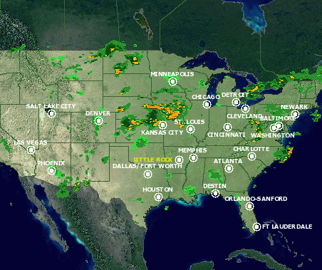
Current Nationwide Doppler Radar From The Weather Channel.

The (HPC)'s Sfc Analysis/Radar/Watch & Warning Composite, & Sfc Analysis With Obs Map Loops.


Above...The Current NWS NEXRAD DIFAX CHART, The Aviation Weather Center (AWC) - National Radar Composite With Echo Tops, The NWS 2km Composite Reflectivity Mosaic From SPC, Five Current NEXRAD NIDS Site Selection Maps From....UCAR, University of Michigan (UOM), NWS RIDGE, & Plymouth University, Three Current Nationwide NEXRAD Mosaics From Plymouth and Albany Universities, The AWC's Convective, Icing, & Turbulence Airmet & Sigmet Charts, & The (ZME) Memphis Center Weather Service Unit's Collaborative Convective Forecast Product Thunderstorm Graphics Maps. Click On Imagery For Enlarged Views and Loops. Click Here For Current Canadian Doppler Radar From Environment Canada's Weatheroffice.
The Following National Weather Service (NWS) NEXRAD WSR-88D Doppler Radar Links Are Public Domain And Not Copyright Protected.
The Latest Collaborative Convective
Forecast Products from the NWS Aviation Weather Center.
The Latest NWS WSR-88D Guidance For The National Convective
Weather Forecast Product.
National Weather Service LAMP Convection and Lightning Comparison Images and Lightning Forecast Products.
The Official National Weather Service
NEXRAD WSR-88D Doppler Weather Radar Site.
The Backup Official National Weather Service
NEXRAD WSR-88D Doppler Weather Radar Site.
The National Weather Service's Combined National Doppler RIDGE Radar And Warning Display Mosaic.
The College Of Dupage's Nationwide NEXRAD WSR-88D Doppler Weather Radar Links.
The UCAR-RAP Current Real-Time NEXRAD WSR-88D Doppler Weather Radar Animations.
The Plymouth Vortex Current Real-Time NEXRAD WSR-88D Doppler Weather Radar NIDS Map.
The University of Michigan's NEXRAD
WSR-88D Doppler Weather Radar and Satellite Menu.
The Latest NWS NEXRAD WSR-88D Doppler
Weather Radar Coded Message Chart With Tops.
The Latest NWS NEXRAD WSR-88D Doppler Radar Coded Message Reflectivity Mosaic.
The Latest NEXRAD WSR-88D Doppler Radar Six Hour Coded Message Reflectivity Loop.
Click Here To Go To The The Latest SPC Hourly Mesoscale Analysis.
Above - Click on the Little Rock National Airport's Arriving and Departing Flight Tracking Map.
Click The Link For Current Aviation Weather From The NWS Memphis Center Weather Service Unit.


The (ZME) Memphis CWSU's AIRMET & SIGMET Charts, & Metro Impact Statements (MIS).

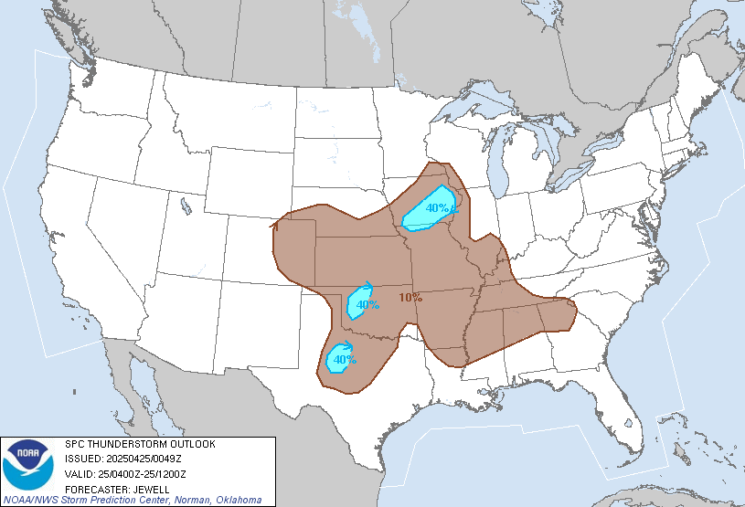
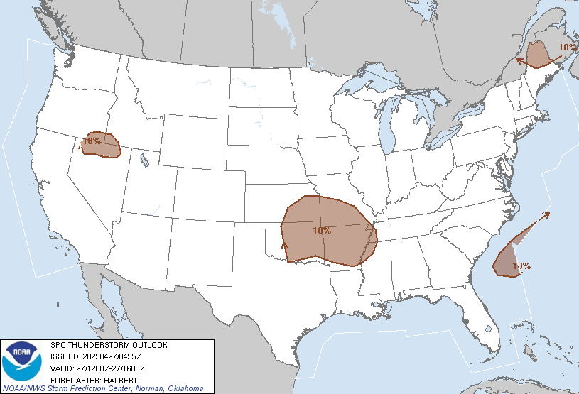
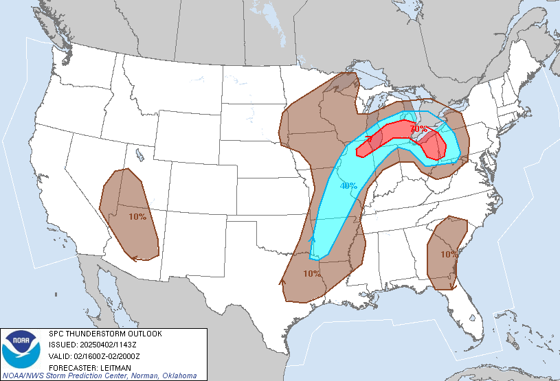
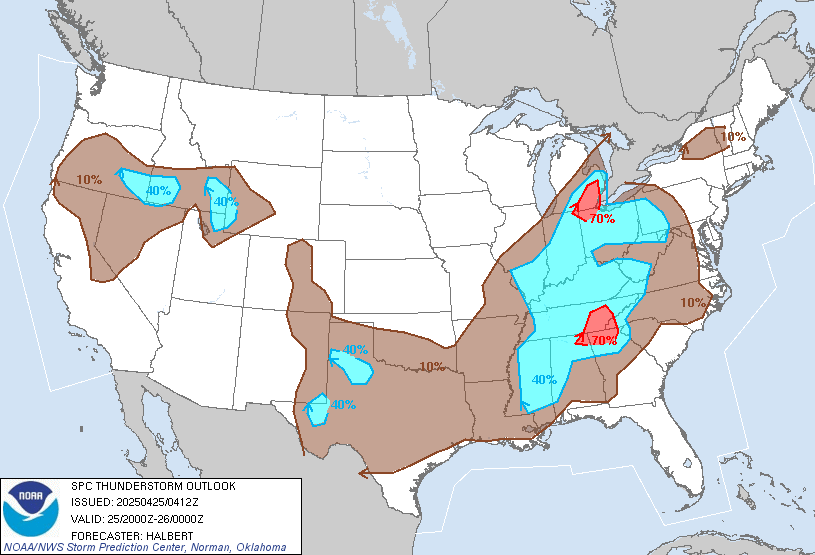
Also, Click To See The (SPC)'s Day 1 Enhanced Thunderstorm Probability Graphics.
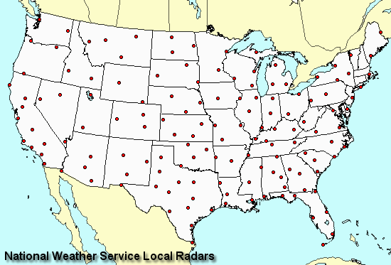
Above - Click On The Map To Check Out A Severe Weather Climatology For Each WSR-88D From The Storm Prediction Center.
Would you like to learn more about NEXRAD or TV Doppler Radar? These next 10 links can help.
The National Weather Association
Remote Sensing Committee's Radar Page.
The National Weather Association
Training Committee's WSR-88D Doppler Radar Links.
WW-2010 Radar Meteorology Online Remote Sensing Guide From The University Of Illinois.
An Introduction To The WSR-88D - A Tutorial From NOAA's Warning Decision Training Branch.
A Severe Weather Climatology For Each WSR-88D From The Storm Prediction Center.
Using WSR-88D Shear Products During Severe Storm Events. - George Wilken Of NWSFO LZK.
Predicting Tornado Touchdowns & Dissipations with the WSR-88D After the Tornado Outbreak of 03/01/1997.
By John A. Lewis III, of NWSFO Little Rock, AR .
WSR-88D Doppler Radar Adaptable Parameter Optimization Of The MESO/TVS Algorithm
By David Matson of National Weather Service, Little Rock, Arkansas.
Thunderstorm Outflow Boundary Detection Using The WSR-88D. By Meteorologist Jeff Naby.
The History Of Weather Radar from NOAA Magazine.
You May Also,
Click Here To Go To The Satellite Center,
Go To The Natural Hazard Maps & Models Center, Or,
Back To The Main Office.